
GeoAI at Scale, Simplified.
The SpatialScale geospatial cloud platform was designed to help you easily discover, inventory, store, and analyze location based data at cloud scale.
Discover the future of geospatial analysis with SpatialScale. Our advanced GeoAI platform is designed to help you easily manage, analyze, and visualize geospatial data at cloud scale. From drone surveying to LiDAR mapping, SpatialScale simplifies your workflow, so you can focus on what matters most—turning data into actionable insights.
Built with You in Mind
-
Data Management
With SpatialScale’s cloud storage solutions, say goodbye to capacity limits and infrastructure constraints. Store, manage, and access your geospatial data effortlessly, no matter the size
-
Powerful Compute
Our platform is powered by industry-leading AWS compute resources, ensuring that your analyses are fast, cost-effective, and efficient. Save time and reduce costs while optimizing your resources.
-
Full SAAS Support
Customize your geospatial workflows with ease. SpatialScale provides all the tools you need to build, automate, and optimize your analytical processes, making complex GeoAI tasks more accessible than ever.
A Complete Geospatial Solution
SpatialScale was crafted by GIS professionals and cloud engineers to bring the power of cloud-native ETL, training, and inference workflows to GIS practitioners, SaaS providers, and digital enterprises.
A Suite of Tools at Your Disposal
-

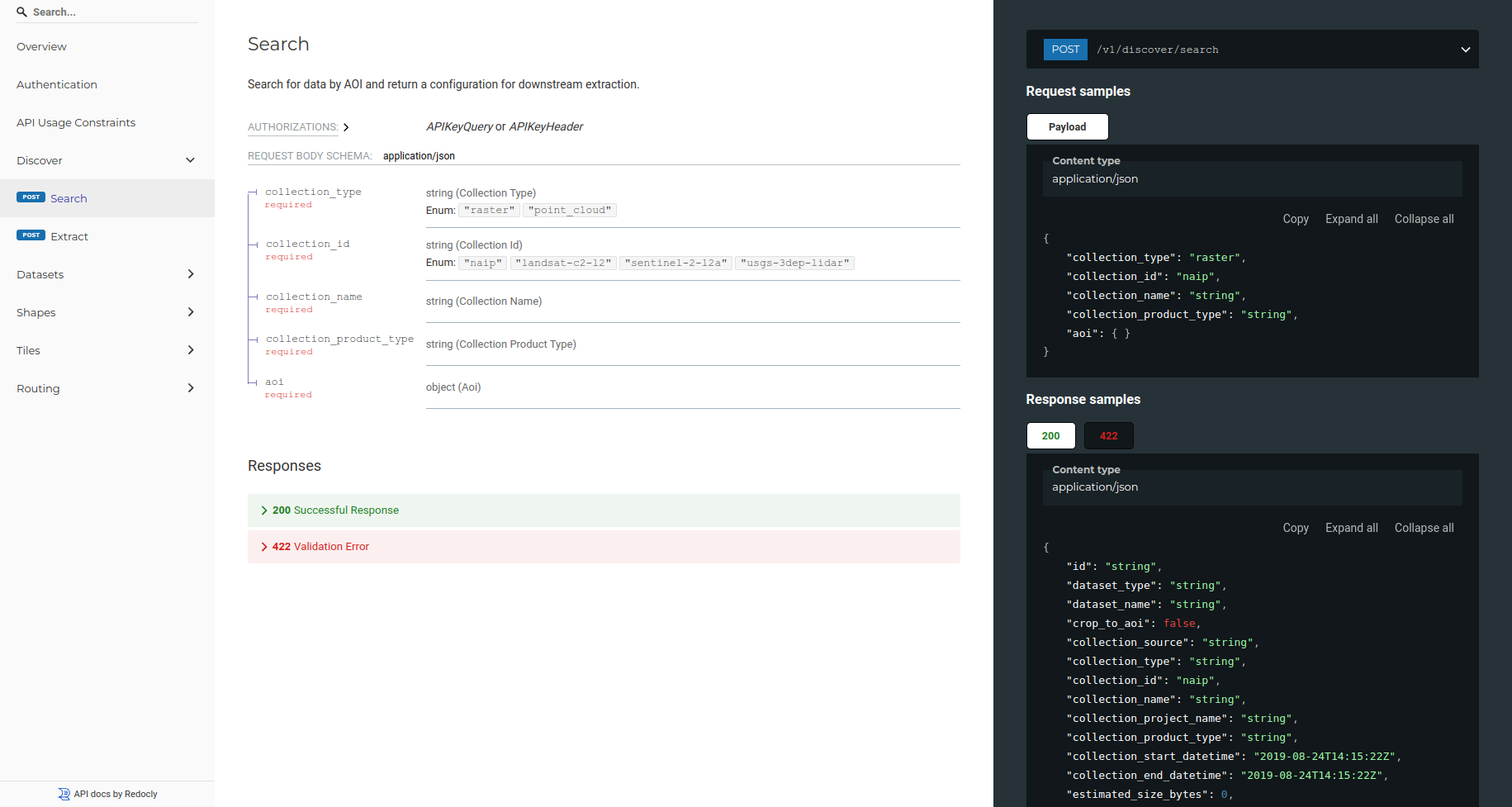
Data Discovery
Easily locate and integrate a wide range of geospatial datasets, including satellite and aerial photos, point clouds, and weather data. Our platform constantly adds new data sources to keep your analyses up to date.
-

3D Visualization
Leverage our state-of-the-art visualization engines to display point clouds, raster, vector, and other data types in full resolution. With continuous zooming and seamless detail changes, you can explore your data like never before.
-

Multi-Sensor Data Fusion
Combine data from multiple sensors to create new models and products for visualization or advanced analytics. SpatialScale makes it easy to fuse diverse geospatial data sources for deeper insights.
-

Point Cloud Classification
Utilize cutting-edge AI and ML models to perform complex 3D data analysis at cloud scale. Our platform accelerates the classification process, delivering accurate results in a fraction of the time.
-

Change Detection
Monitor and visualize changes over time in your remotely sensed data. Our advanced differencing tools provide clear insights into spatial changes, helping you stay ahead of the curve.
-
Microservices Architecture
Our solutions are built on a microservices architecture, enabling rapid development and deployment, ensuring that your geospatial applications are always up to date.
Gabriel Cavazos, Chief Executive Officer, Wrexx
“SpatialScale made it easy to rank, classify, and visualize motorcycle incidents across Texas. This is amazing!”

Plans and pricing
Choose the plan that best fits your business needs. Whether you're an individual user or a large enterprise, SpatialScale offers flexible pricing to match your requirements.
Our low code platform gives developers tools to build better mapping, navigation, and search experiences across platforms with ease.
-
We accept all major credit and debit cards, as well as direct bank transfers from US banks.
-
Yes, you can choose to be billed monthly or annually when upgrading to a paid tier.
-
Yes, as your usage grows, volume pricing is automatically applied.
-
Pro account users receive guaranteed faster responses on the community forum.
-
No worries, we’ll reach out to you to resolve the issue.
Latest posts


